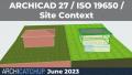
A variety of contextual 3D information is available from various sources including some from government open data libraries. See how some of these datasets can be located and then converted to be ready for use with Archicad by using freely available open source software. Learn how to import that data into Archicad and get it ready for use in your Archicad projects or export it to 3D visualisation software.
Key Learning Objectives
- Manipulating point clouds for use with Archicad using open source software.
- Creating terrain meshes from point clouds or other data sources and applying aerial photography as a texture.
- Converting and importing 3D data into Archicad using open source software.

Andrew Zarb, 3D Project Officer, Sunshine Coast Regional Council
Andrew Zarb is the 3D project officer at Sunshine Coast Council. His expertise was relied on in the creation of a complete 3D computer model of the... - View profile